
With an increasing number of satellites launched in recent years and advances in the image analysis methods, remote sensing data has proven itself as a cheap and very valuable source of information for planning, construction and monitoring of offshore wind farms (OWF).
Here are a few examples of satellite-based services, used by professionals:
1. Mapping of water depths and seabed dynamics
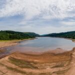
Understanding of the seabed dynamics is highly relevant when planning to reduce potential risks of exposure of cables and infrastructure. Using advanced image analytics, it is possible to convert raw satellite images into quantified information of the seabed around OWFs. The information can either be derived as absolute water depth values in shallow waters (down to 25m), or as relative information highlighting the geomorphological dynamics, such as estimation of migration rates (metres per year) of sand waves.
DHI has successfully delivered this type of information for OWFs along the US east coast, in the North Sea and in Taiwan Strait.
Satellite image showing sand bars around OWF Horns Rev in the North Sea. Using this type of image data, it is possible to monitor and estimate the seabed dynamics, in this case movement rates of the large scale sand waves. © DHI, contains Copernicus Sentinel data.
2. More accurate and reliable metocean data
For years, satellite remote sensing data has provided incredible value to metocean processes and characteristics in relation to offshore wind. With the use of altimeters and radar sensors mounted on satellites, it is possible to derive several different parameters related to quantification of metocean conditions, such as winds, waves and sea surface height – today this is even possible very close to a coastline.
Not only is satellite data of significant value for wind resource estimation, it also allows for the establishment of an accurate and robust environmental design basis for building offshore wind turbines.
Today, it is common to apply aggregated measurements from different types of satellites and multiple passes in calibration and validation of numerical hydrodynamics and wave models, the so-called hind cast models – in combination with in situ synoptic observations. The outcome of the hind cast models are accurate time series (typically 30-40 years) of metocean data to be used for planning, design, construction and operation of an offshore wind farm.
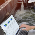
Such data is readily available on modern metocean data platforms such as DHI’s MetOcean Data Portal, where long term data can be downloaded easily and quickly for subsequent processing and analysis. Before data (e.g. wave data) is downloaded, the data is always instantly validated against satellite data to assure the quality and robustness.

Screenshot from DHI’s MetOcean Data Portal, providing easy access to metocean data and instant validation against satellite data, in this case along the US East Coast. © DHI
3. Detailed monitoring of maintenance activities in near-real-time
As most satellites are in constant orbit around the Earth, they provide a mean for getting situational awareness when needed. Optical and radar (SAR) satellites can provide very detailed imagery down to 25 cm in detail level, and with no HSE risks associated. The images are a highly cost-efficient way of getting updated intel on specific OWF sites, allowing monitoring of specific maintenance or similar activities. The images can be delivered within just hours after the acquisition and thus provide the situational overview in near-real-time.
With the increasing amount of satellites, it is now possible to get a daily snapshot in very high resolution of any OWF site in the world. This capacity will be even further increased within the next few years where sub-daily (down to hourly) imagery is expected.
Contact us
Interested in hearing how satellites can benefit your OWF projects? Get in touch, and we will find a solution that fits your needs.