

With frequently changing climatic conditions, decision makers are facing the challenge of protecting human lives and precious assets against flooding from rivers, the sea and storm surges in urban areas along coasts.
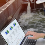
Fortunately, web-based services and solutions can support decision makers in their response to the comprehensive challenge posed by coastal flooding. Taking this into account, we asked Nils Drønen, Chief Coastal Engineer at DHI, a few questions about the core advantages of web-based modelling solutions and how they can be explored to help decisions makers predict and prepare for future flood events.
Q: What are the core challenges decision makers are facing when it comes to coastal flooding?
When talking about flooding, it’s closely related to changing climatic conditions. Decision makers have limited knowledge and overview of what will happen. On a global scale, gradually increasing sea levels and storm surges are affecting many urban areas located near coasts. This steady increase in water levels will extend over a long period, which means the real trouble may not start to appear until 50-100 years from now. In this uncertain perspective, decision makers find it difficult to get a tangible feeling of what will happen and when to act.
Q: How can online planning make it easier for decision makers to prepare for flooding and climate change?
Online tools can simulate different scenarios. For example, you can test what will happen if sea levels rise, or how urban areas are impacted if a storm surge hits the area. By doing so, you get a better idea of the consequences, and you can quantify the losses caused by flooding. Using online tools, users can calculate potential impacts and damages of storm surges several years from now and simulate what the situation would look like if no action is taken. In this regard, the models can be used to predict future scenarios and see if there is a tipping point in which we will start to experience serious damage.
Based on this information, decision makers get an overview of which mitigation measures to introduce, such as building dikes or installing pumps. As such, you start to define your climate adaptation plan by testing the effect of the plan while comparing investments to potential losses.
Q: Compared to more traditional flood mitigation methods, what are the advantages of web-based solutions?
First of all, a web-based solution makes it possible for different stakeholders who are engaging in the same issue to access the system simultaneously, making it a tool suited for dialog between stakeholders.
Adding to this, DHI’s technologies combine web-based solutions with numerical computer models that can simulate complicated flooding challenges. This combination simulates not only coastal flooding but also what happens in areas near the coast if, for example, a nearby river is flooded. These models are typically more sophisticated compared to older methods that use static mapping since these methods don’t necessarily take into consideration that an extreme flood event is dynamic. Older models do not accurately describe the actual flood event – they will typically be more conservative and overestimate predicted flood areas. Thereby, compromising the development of an optimal investment plan. Sophisticated solutions simulate how the water flows into the urban area in time and space. Despite the fact that we’re talking about coastal flooding, the flood can impact urban drainage networks, making it a more complicated challenge.
Although these are very tricky and complicated challenges, the idea is that web-based solutions take the complex technologies and hide them behind a user-friendly interface. By doing so, the user interface is designed for users who are close to the planning and decision-making. These users are not required to be modelling experts in order to use the models.
Q: How can the solutions support both long-term and short-term planning?
In cases where you are planning long-term permanent investments such as new infrastructure to prevent flooding, you could consider how the risk of areas being flooded can be reduced by integrating emergency planning in the decision. In other words, by deploying web-based solutions, we can look into the future to see what kind of permanent structures and flood preventing measures we want to introduce. Yet, at the same time, we can also plan an emergency or early warning system that covers the remaining risks that are not covered by permanent structures. In this way, it is possible to work with short-term emergency planning integrated with long-term, permanent flood prevention.
Q: In connection to this, how can web-based solutions be used in a larger perspective?
Online tools and web-based solutions are interesting because they can provide information on different organisational levels, including how to distribute mobile materials and resources across borders. On regional levels, web-based solutions could help municipalities prepare for emergency flooding or be introduced as tools on national levels to help prepare for long-term flood mitigation. Ultimately, on a transnational level, one could imagine using these tools and models all over Europe to simulate and prepare for cross border flooding.
Empower your coastal resilience planning
At DHI, we strive to share our knowledge of coastal resilience planning to help you mitigate the risks of flooding. Contact us and learn how our digital, custom solutions can empower your decisions.