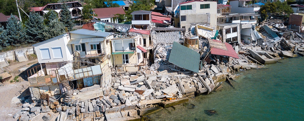

No thanks to climate change, extreme weather events are getting more frequent, intense and unpredictable. A publication by the UN Office for Disaster Risk Reduction (UNDRR) highlights that in the past 20 years, weather-related disasters made up approximately 90% of major recorded disaster events. Although loss of human lives may be decreasing, economic impact – especially that of informal economies and uninsured losses – are on the rise.
However, having access to risk information can help stakeholders make better decisions to mitigate the impact of natural disasters on their communities and economy. Learn more.
Q: What are the challenges of decision-making that governments, institutions and local leaders need to go through when planning for disaster risk management?
A: Disaster management has historically been associated with crisis management or handling ground response efforts in emergency situations. This type of activities has been and is most relevant when supported with the deployment of early warning systems. The more recent past has seen a recognition that the benefits of prevention of disaster impacts on infrastructure, economic sectors and population far outweigh those of response activities alone. It is clear that agencies in charge of disaster management or planning related activities need to capture the probable consequences of extreme events on our society to support decisions and prioritise investments.
Quantitative risk modelling is the cornerstone of such exercise as it allows us to understand and directly compare the need for and benefits of implementing different risk management activities, such as zoning and building codes, emergency planning, and the scale of contingency budgets and recovery efforts. Assessing hazards and impacts can take place at different levels and scales. Either very detailed and localised or coarser and regional. Both types of approaches have their benefits and serve different purposes in decision-making and prioritisation. In practice, understanding, communicating and finally integrating risk into decision-making is still a challenge in most parts of the world.
Q: What types of information are important when it comes to assessing and forecasting extreme weather phenomena and managing potential consequences?
A: Risk assessment for planning purpose will help create the full information base for impact analysis while supporting near real-time or forecast-based risk management efforts (impact-based forecasting or parametric insurance). Key information includes typical datasets required for setting up and calibrating hydrological and flood models (hazard), spatial distribution of population and assets classified into meaningful typologies (exposure) and the susceptibility of these elements to different hazard intensities (water depth, flow velocities).
The outcome of such work is generally summarised in risk metrics available at different aggregation levels (single asset, assets portfolios, economic sectors) including Loss Exceedance Curves, which will identify the probabilities of losses above certain thresholds and the Annual Average Loss, a single loss metric particularly useful for cost-benefit analysis of scenario comparison.
Understanding the frequencies of events, particularly for compound flooding (storm surge and river flooding) and being able to extrapolate beyond past observations are critical for getting the risk metrics right. Decisions on mitigation strategies shall come then from the analysis of the spatial (possibly temporal) distribution of assets and losses, the vulnerability of the assets (or receptors) and the source and pathways leading to hazard occurrences. Entering the sphere of operational and extreme event forecast, the reliability (and understanding of uncertainties) of weather and hydrological data and models and the lag time to produce alerts will be key. Event information, including dynamics, extent and impacts will help devise emergency mitigation and evacuation efforts.
Q: What kind of competencies should stakeholders look out for when considering hydrological risk management solutions?
Selecting the right tools and solutions should be based on a proper understanding of the needs required to develop, maintain and operate the system, the resources available (data, skills, IT infrastructure) and where you are in your journey towards actively managing risks. Some models and system allow us to get started relatively quickly for screening issues, using simplified modelling approaches and covering the full risk modelling chain from beginning to end. At a more mature stage, modular and interoperable systems can provide access to more complex hazard and risk modelling components adapted to the level of technical competences of the users. Beyond the modelling tools and approaches, three aspects will matter to ensure better uptake and long-term integration of risk information in decision making:
- At the end of the modelling chain, the information produced should be objective, simple and clear to allow efficient communication between different user groups. Adopting a risk-based approach should address this.
- The system, once fully operational, should allow users to access, test and compare scenarios with limited or no involvement of domain experts to expedite analysis (in emergency situations), iterations (for revisiting mitigation plans) or optimisation
- Analysing risk requires information to be available and produced between different agencies. The investment required to build and maintain a comprehensive information database calls for a long-term commitment to a robust system, professionally documented and supported internally and possibly externally.
Q: What do opinion leaders predict as the future of hydrological risk management in this digital age?
A: Over the past decade, we have experienced an exponential increase in access to computational power and data sources (remote sensing, crowd sourced) merged with creative use of non-traditional data and new predictive techniques (e.g. AI). Data quality and resolution, increased precision of climate, meteorological and hydrological models and forecasts, better integration of hazard and socio-economic and ecological models will keep getting better.
Access to quality and timely information will become universal in the next decade. The challenge for now and in the future will be to integrate this knowledge into daily decisions and long-term planning. This is something that technological advancement should get better at doing, possibly by supporting first specific sectors (insurance, tourism, agriculture, critical infrastructure) but ultimately by being able to capture societal systems as a whole to ensure sustainable development and long-term resilience.
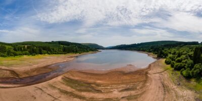
Know your options for protecting societies from flood & drought disasters
Here’s what governments, authorities and emergency responders can do to better protect society from this growing threat. Contact us to learn more about the range of integrated solutions available.